

A road beside a development site may not be publicly maintained, and a path crossing the land may remain a public right of way. Highways authority due diligence helps establish responsibility for a route and how existing or proposed rights of way could affect access, design and development plans.
It’s easy to assume that a visible road is adopted or that a route can be changed as part of a project. In practice, maintenance responsibility and public access depend on the route’s status and the relevant authority. In England and Wales, Section 41 of the Highways Act 1980 establishes a duty to maintain highways maintainable at public expense, according to the UK legislation register.
This guide explains who manages public highways across the UK, how adoption and development agreements affect due diligence, and which access issues to examine early. It also covers public rights of way and proposed diversions, helping you understand how they may affect a site’s constraints and next steps.
Key Takeaways
- Understand how section 38 and section 278 agreements can affect highway adoption and development plans.
- Distinguish between a road’s adoption status and the extent of the publicly maintained highway.
- Identify how a public footpath or bridleway within a site can constrain development proposals.
- Recognise how a ransom strip may affect legal access, finance and future saleability.
- Use early, structured assessment of highway records and rights of way to bring access risks into project decisions.
How do section 38 and section 278 agreements affect highway adoption and development due diligence?
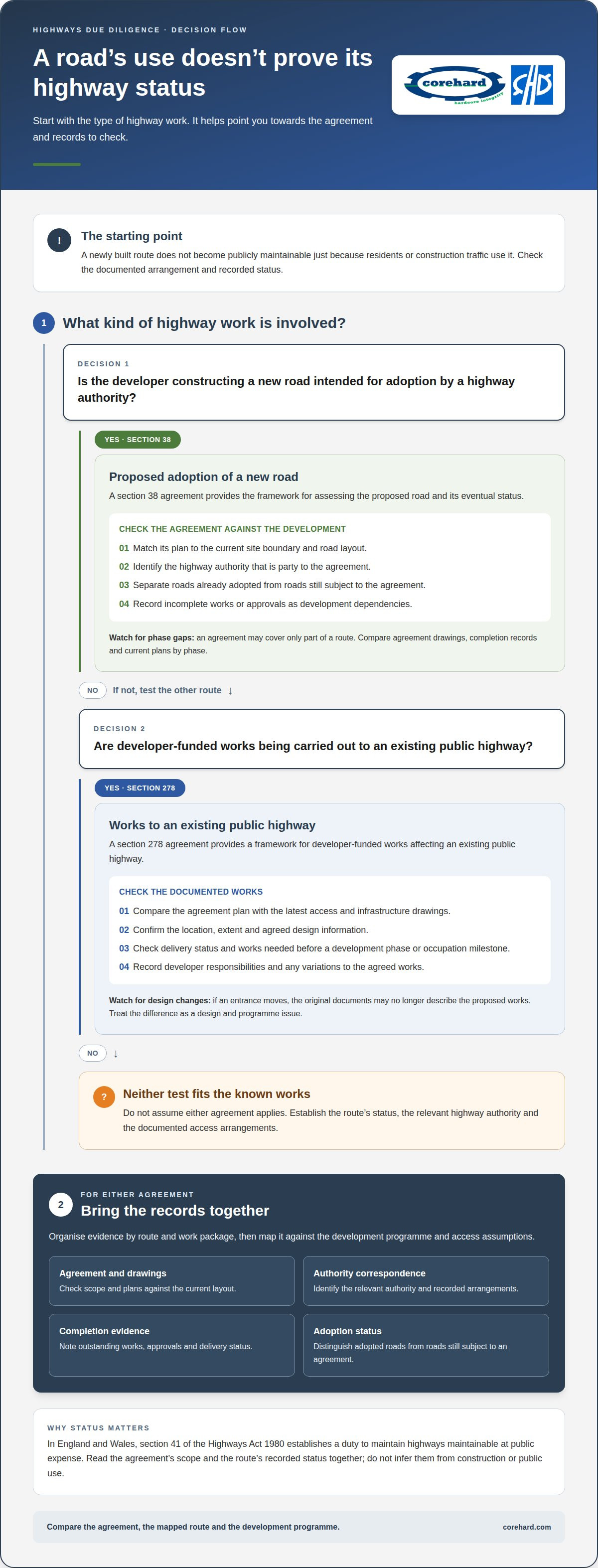
Section 38 and section 278 agreements shape how development-related highway works are approved, delivered and recorded. Their terms can affect site access, construction sequencing, ongoing maintenance and whether a new road becomes publicly maintainable. Due diligence should therefore establish which agreement applies, what it covers and whether its obligations align with the development programme.
Section 38: proposed highway adoption
A section 38 agreement is used where a developer constructs a new road intended for adoption by a highway authority. Adoption means the authority takes responsibility for maintaining the road as a highway maintainable at public expense. The agreement provides the framework for assessing the proposed road and its eventual status.
For a development site, the distinction between a road intended for adoption and an adopted road is material. A newly built route does not become publicly maintainable merely because residents or construction traffic use it. Section 36(1) of the Highways Act 1980 defines which highways are maintainable at public expense, so the agreement and adoption records matter alongside the site plan.
Review the agreement against the development layout and delivery stages. Identify which road sections it covers, the approving highway authority, outstanding works and any recorded steps towards adoption. Clarify whether access depends on a route that remains under the developer’s control.
- Match the agreement plan to the current site boundary and road layout.
- Identify which highway authority is party to the agreement.
- Separate roads already adopted from roads still subject to the agreement.
- Record incomplete works or approvals as development dependencies.
For example, a housing scheme may show a connecting road on its approved layout, while the agreement covers only the first phase. Assuming the entire route is adopted could misrepresent access arrangements for later plots. Compare agreement drawings, completion records and current plans by phase to identify any mismatch.
Section 41 of the Highways Act 1980 establishes a duty to maintain highways maintainable at public expense, according to the UK legislation register. That duty makes the adoption boundary relevant to long-term responsibility. The agreement’s precise scope and the route’s recorded status should be read together, rather than inferred from road construction or public use.
Section 278: works to an existing highway
A section 278 agreement concerns developer-funded works to an existing public highway. It provides a framework for works affecting that highway, such as changes needed to serve a development. Unlike section 38, its central due-diligence issue is the alteration of an existing route, not adoption of a newly constructed road.
Review the section 278 documentation alongside the planning layout and access design. Confirm the location and extent of works, the relevant highway authority, the agreed design information and the status of delivery. A mismatch between the agreement drawings and the live development design may affect access, junction arrangements or construction sequencing.
- Compare the agreement plan with the latest access and infrastructure drawings.
- Identify works that must precede a development phase or occupation milestone.
- Check which responsibilities remain with the developer during delivery.
- Record any variation that could change the approved highway works.
If a site entrance moves after the agreement is prepared, the original documents may no longer describe the proposed works. Treat this difference as a design and programme issue rather than assuming the agreement covers the revised layout. Clear records help align construction decisions with the documented arrangements.
Across both agreements, highways authority due diligence connects legal status, design evidence and delivery responsibilities. The Highways Act 1980 is the main legislation defining highway authorities in England and Wales. Establishing the relevant authority and agreement scope helps distinguish public highway obligations from developer commitments.
Organise evidence by route and work package: the agreement, drawings, authority correspondence, completion evidence and adoption status. Map each item against the development programme and access assumptions. This makes gaps visible early, supports sound project decisions and gives technical teams a clear basis for managing highway-related dependencies.
The UK legislation register states that section 58 of the Highways Act 1980 provides a statutory defence to the duty to maintain highways in England and Wales. It records that the section 41 (1A) duty concerning snow and ice on highways came into force on 31 October 2003.
What are the main risks and red flags in highways due diligence for a property or development site?
A road beside a site may look like a dependable access route, but its status or extent could tell a different story. In England, a local search can indicate whether a highway is adopted, while a highways search can show the extent of the adopted highway. Treating these records as interchangeable can leave a boundary or access issue undiscovered.
Adoption and highway extent
An adopted highway is a public highway maintained at public expense; its recorded extent identifies the land included. A local search and a highways search answer different questions, so assess both against the property boundary and proposed access. If a site plan shows a road along a frontage, compare the mapped highway extent with the actual boundary rather than assuming the entire frontage is publicly maintained.
Timing can also be a due-diligence risk. Some UK councils take over 100 working days to provide highway extents information. For a transaction or development programme, that delay can affect when access assumptions are resolved. Build the information request into the project timetable, and record any reliance on an unverified boundary as an open issue rather than treating it as settled.
A useful review links each access point to its supporting evidence: the search result, the relevant plan and the site layout. If those documents show different boundaries, identify the discrepancy and assess its effect on the proposed entrance, servicing route or development parcel. This turns an unclear map into a defined design question.
Public rights of way
A public right of way is a route available to the public, even when it crosses privately owned land. In England, a public footpath or bridleway within a property boundary remains a public right of way, and the property owner must not interfere with it. Its presence can constrain site layout, fencing and construction proposals.
For example, a proposed building footprint may overlap a footpath shown crossing the site. Identify this conflict before treating the layout as deliverable. Map the route against the boundary and proposed works, then document where the design may need to preserve the route or seek a formal change.
A proposed change to a public right of way may involve a formal process, and a diversion may need an alternative route. Do not treat a proposed order as though the route has already changed. Show the existing path in the constraints plan and distinguish the current position from the outcome sought in the application.
Ransom strips and legal access
A ransom strip is a narrow piece of land between a property and a public road that may prevent direct legal access. In England, a property may lack legal access from the public road if a ransom strip lies between its boundary and the highway and the buyer has no rights over that strip.
A visible gap between the title boundary and the mapped highway extent is one warning sign. Another is a strip whose owner is difficult to identify because the land may be unregistered. Using a track does not, by itself, establish rights over the intervening land.
The consequences can extend beyond site access. In England, a ransom-strip access issue may lead lenders to refuse finance to potential buyers, affecting future saleability. Record the strip’s location, ownership evidence and any access rights shown in the property documents. This helps frame the issue for valuation, funding and development decisions without assuming an informal route resolves it.
For a structured review, group red flags by their impact on project decisions:
- Access: establish whether the site connects legally to the public road.
- Boundary: compare adopted highway extent with the property plan.
- Route constraints: plot each footpath or bridleway against proposed works.
- Programme: account for highway information that may take over 100 working days.
These checks help distinguish a mapping discrepancy from a route constraint or access gap. Bringing the evidence together early gives property and development teams a clearer basis for site design, transaction decisions and programme planning.
ISO 31000: 2009 sets out risk management principles, an organisational framework and a process for developing and implementing a risk-based approach. The 1872 Alabama Arbitration held that a government must exercise diligence in proportion to the risks and cannot excuse a failure by pleading insufficient legal means; its listed value is 129.
Corehard
Corehard Ltd helps bring highway responsibilities, access constraints and development requirements into a clear, evidence-led assessment. Its NRSWA & TMA Advisory and NRSWA & TMA Development services support projects where agreements, highway records and proposals need to be considered together.
Where asset condition or compliance evidence is central, Asset Surveys & Condition Reporting and Dynamic Assurance & Compliance can inform project decisions. This support is relevant when highway status, proposed works or site access raise questions that could affect design, delivery or ongoing responsibilities. The aim is to organise technical information so teams can understand the issues and make informed decisions.
Contact Corehard Ltd to discuss your project’s highways due diligence requirements.
Turn highway findings into clear project decisions
Make each unresolved highway matter visible in project decision-making instead of leaving it buried in plans or correspondence. Record the evidence, the affected access or design assumption, the decision it could influence and who is responsible for progressing it. This creates a practical basis for managing dependencies as the project develops.
A disciplined highways authority due diligence process also helps teams distinguish information that changes the scheme from information that simply needs to be retained for governance. This supports clearer discussions between development, engineering and commercial teams, particularly when designs or delivery plans change. Keep the assessment current as new records or project decisions emerge.
Where specialist input would help bring highway obligations and technical evidence into the same view, contact Corehard about highways due diligence. A well-organised evidence base gives your team a stronger platform for the decisions ahead.
Frequently Asked Questions
What does highways authority due diligence involve in the UK?
Highways due diligence involves assembling and assessing evidence about responsibilities that could affect a property transaction or development decision. A practical output is an evidence register linking each issue to its source document, affected parcel, project assumption and decision owner. For example, if access depends on a route with unclear status, record that dependency against the relevant design or transaction milestone so it remains visible during project reviews.
Which highways authority records and documents should be checked before buying land or property?
Alongside property and search documents, review highway authority correspondence, scheme plans, traffic orders and records of planned works near the land. For development proposals, compare these records with the access strategy, servicing arrangements and phasing assumptions. A document schedule should record each item’s date and coverage, then flag inconsistent boundaries or routes across plans. This helps conveyancing and project teams work from the same evidence set.
How do you check whether a road is publicly maintained and recorded as an adopted highway?
Use relevant search results and highway records to establish the recorded status of the road section serving the property. Make the assessment location-specific: a road can have different status along separate stretches, so the access point and route to the wider network matter. Record the plan or search reference supporting the conclusion, and note any mismatch with the property’s access arrangements for further assessment.
How do you check for planned road schemes, traffic orders, restrictions and compulsory purchase proposals?
Review the relevant authority’s published proposals and project information, then compare scheme boundaries and affected routes with the site plan. Traffic orders and restrictions may influence how vehicles reach or use a site, while a proposed scheme could affect land or access assumptions. Record each proposal’s location, stated status and potential project impact. Revisit the assessment if the development layout or access strategy changes.
What highway rights, easements, stopping-up orders or public rights of way should be investigated?
Assess whether the property depends on access across land outside its ownership, and identify the documents describing that route. Consider whether easements or other rights shown in title materials align with the access actually used or proposed. If the site has multiple entrances, document the legal and practical basis for each separately. This can reveal where a design depends on an access route not addressed by the project evidence.
What steps should a solicitor or developer take to complete highways due diligence in the UK?
First set out the land parcels, access points and project assumptions, then create a document register and issue log. Link each issue to a transaction or design decision and assign an owner to record its resolution. Before completion or design approval, reconcile the evidence with the current site layout and retain supporting records. This creates a clear audit trail and helps prevent unresolved highway matters from being lost between legal and technical workstreams.


